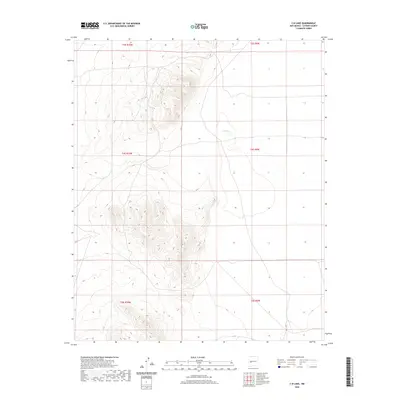
2020 Map of C-N Lake
USGS Topo · Published 2020About this map
The high-altitude terrain of northwestern Catron County dominates this landscape, defined by a series of prominent ridges and basins. C-N Lake is the primary landmark here, sitting in a natural depression surrounded by varying elevations that reveal the complex drainage patterns of this arid region. The map reflects the systematic organization of the Public Land Survey System, showing the intersections of t3s r10w, t3s r9w, t4s r10w, and t4s r9w. This layout illustrates the early 20th-century grid system used to divide and manage large tracts of the New Mexico backcountry, providing a clear view of how these remote townships were structured topographically before modern development.
Find a feature on this map
7 named features on this map. Tap any name to fly to it.
Don’t see what you’re looking for? This feature index may not catch every label — zoom into the map to look around manually.
Map Details
Editions of this 2020 C-N Lake Map
This is the sole edition of this map. No revisions or reprints were ever made.
Other maps of this area

1954 · Tularosa
USGS Topo · 1:250,000

1954 · Socorro
USGS Topo · 1:250,000

1958 · Socorro
USGS Topo · 1:250,000

1958 · Tularosa
USGS Topo · 1:250,000

1962 · Socorro
USGS Topo · 1:250,000

1963 · Anderson Peak
USGS Topo · 1:24,000

1965 · Oak Peak
USGS Topo · 1:24,000
1965 · Sugarloaf Mountain
USGS Topo · 1:24,000
1965 · Kellog Well
USGS Topo · 1:24,000
1965 · Augustine Well
USGS Topo · 1:24,000