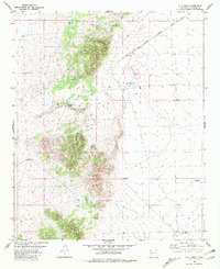
1981 Map of C-N Lake
USGS Topo · Published 1981About this map
The Radio Telescope Track (VLA) cuts a striking diagonal path across this Catron County landscape, representing the northeast arm of the Very Large Array. This high-desert terrain is defined by its necessity for water, evidenced by a network of scattered water sources including C-N Lake, Graham Well, and Espanola Well. The distribution of these features across the quadrangle suggests a territory dedicated to large-scale ranching operations, where named points like the West Pasture Windmill served as critical landmarks for land management. To the south and east, additional infrastructure like Woods Well and Stien Well further illustrate the sparse but vital human footprint on this arid plateau. The presence of a dedicated Antenna site near the telescope track underscores the region's mid-century transition into a global center for radio astronomy, set against a traditional backdrop of western livestock grazing.
Find a feature on this map
13 named features on this map. Tap any name to fly to it.
Don’t see what you’re looking for? This feature index may not catch every label — zoom into the map to look around manually.
Map Details
Editions of this 1981 C-N Lake Map
This is the sole edition of this map. No revisions or reprints were ever made.
Other maps of this area

1954 · Tularosa
USGS Topo · 1:250,000

1954 · Socorro
USGS Topo · 1:250,000

1958 · Socorro
USGS Topo · 1:250,000

1958 · Tularosa
USGS Topo · 1:250,000

1962 · Socorro
USGS Topo · 1:250,000

1963 · Anderson Peak
USGS Topo · 1:24,000

1965 · Oak Peak
USGS Topo · 1:24,000
1965 · Sugarloaf Mountain
USGS Topo · 1:24,000
1965 · Kellog Well
USGS Topo · 1:24,000
1965 · Augustine Well
USGS Topo · 1:24,000