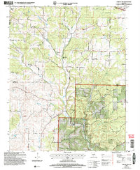
2004 Map of Cabool SW
USGS Topo · Published 2006About this map
The Mark Twain National Forest dominates the southeastern quadrant of this Ozark landscape, where the headwaters of the North Fork Pleasant River and Panther Creek carve through the terrain. The social history of the rural districts is preserved through numerous named school sites and country churches, such as Union Chapel and Pleasant Hill Ch. The prevalence of historical school sites, including Excelsior Sch (Site), Gum Spring Sch (Site), and Lone Star Sch (Site), points to a previously denser pattern of small communities that once supported these local centers. In the north, the terrain transitions toward more open areas near Dogwood and McCall, while the south is marked by the rugged drainage of Greasy Creek and Creasy Hollow. Geologic interest is found at Onyx Cave, located just off Onyx Cave Road near the Wright and Texas County line.
Find a feature on this map
39 named features on this map. Tap any name to fly to it.
Don’t see what you’re looking for? This feature index may not catch every label — zoom into the map to look around manually.
Map Details
Editions of this 2004 Cabool SW Map
This is the sole edition of this map. No revisions or reprints were ever made.
Other maps of this area

1937 · Buckhart
USGS Topo · 1:48,000

1939 · Topaz
USGS Topo · 1:62,500

1941 · Topaz
USGS Topo · 1:62,500

1943 · Buckhart
USGS Topo · 1:62,500

1945 · Harrison
USGS Topo · 1:250,000

1945 · Buckhart
USGS Topo · 1:62,500

1949 · Harrison
USGS Topo · 1:250,000

1950 · Cabool SW
USGS Topo · 1:24,000

1951 · Mountain Grove South
USGS Topo · 1:24,000

1951 · Cabool SE
USGS Topo · 1:24,000