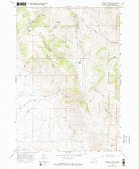
1965 Map of Caboose Canyon
USGS Topo · Published 1968About this map
Beaverhead National Forest land defines this corner of Montana, where a complex network of high-elevation canyons and intermittent creeks converge toward the valley floor. The map highlights the localized agricultural and mineral interests of the mid-1960s, notably at the Peterson Ranch and several unidentified prospects located near the southern drainage of Deadman Creek. The topography is dominated by dramatic relief, with labels marking distinct landforms like Caboose Canyon, Patterson Canyon, and the curiously named Pileup Canyon.
Find a feature on this map
26 named features on this map. Tap any name to fly to it.
Don’t see what you’re looking for? This feature index may not catch every label — zoom into the map to look around manually.
Map Details
Editions of this 1965 Caboose Canyon Map
2 editions found
Other maps of this area

1955 · Dubois
USGS Topo · 1:250,000

1957 · Scott Peak
USGS Topo · 1:62,500

1957 · Edie Ranch
USGS Topo · 1:62,500

1958 · Dubois
USGS Topo · 1:250,000

1965 · Caboose Canyon
USGS Topo · 1:24,000

1965 · Gallagher Gulch
USGS Topo · 1:24,000

1965 · Graphite Mountain
USGS Topo · 1:24,000

1965 · Dixon Mountain
USGS Topo · 1:24,000

1965 · Dell
USGS Topo · 1:24,000

1965 · Island Butte
USGS Topo · 1:24,000