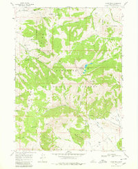
1968 Map of Cache Peak
USGS Topo · Published 1980About this map
Albion Mountains high country dominates this late 1960s survey, showcasing a landscape defined by significant elevations and glacial features within the Sawtooth National Forest. The peaks of Mount Independence and Cache Peak tower over the Independence Lakes, while the western slopes descend through Slide Canyon toward the small settlement at Fairchild. This area is marked by a complex network of seasonal water sources and named springs, including Salt Lick Spring and Heath Spring, which were vital for the local livestock and forest management of the era.
Find a feature on this map
48 named features on this map. Tap any name to fly to it.
Don’t see what you’re looking for? This feature index may not catch every label — zoom into the map to look around manually.
Map Details
Editions of this 1968 Cache Peak Map
Other maps of this area

1954 · Pocatello
USGS Topo · 1:250,000

1958 · Pocatello
USGS Topo · 1:250,000

1968 · Almo
USGS Topo · 1:24,000

1968 · Cache Peak
USGS Topo · 1:24,000

1968 · Basin
USGS Topo · 1:24,000

1968 · Jim Sage Canyon
USGS Topo · 1:24,000

1968 · Marion SE
USGS Topo · 1:24,000

1968 · Elba
USGS Topo · 1:24,000

1968 · Mount Harrison
USGS Topo · 1:24,000

1968 · Lyman Pass
USGS Topo · 1:24,000