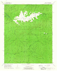
1964 Map of Cades Cove
USGS Topo · Published 1967About this map
The settlement of Cades Cove remains the centerpiece of this mid-1960s study, preserved within the Great Smoky Mountains National Park. The landscape is a mix of agricultural history and wild terrain, centered on the Cades Cove Loop Road which connects numerous pioneer-era homesteads and structures. Many family-named landmarks are visible, such as the John Oliver Cabin, the Becky Cable House, and the Elijah Oliver Place, illustrating the community that existed before the park's establishment.
Find a feature on this map
154 named features on this map. Tap any name to fly to it.
Don’t see what you’re looking for? This feature index may not catch every label — zoom into the map to look around manually.
Map Details
Editions of this 1964 Cades Cove Map
2 editions found
Other maps of this area

1886 · Knoxville
USGS Topo · 1:125,000

1892 · Knoxville
USGS Topo · 1:125,000

1894 · Knoxville
USGS Topo · 1:125,000

1895 · Knoxville
USGS Topo · 1:125,000

1901 · Knoxville
USGS Topo · 1:125,000

1933 · Bushnell
USGS Topo · 1:62,500

1935 · Fontana
USGS Topo · 1:24,000

1935 · Calderwood
USGS Topo · 1:24,000
1935 · Tapoco
USGS Topo · 1:24,000
1935 · Blockhouse
USGS Topo · 1:24,000