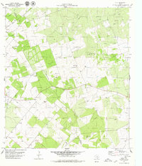
1979 Map of Cadiz
USGS Topo · Published 1979About this map
Cadiz serves as the focal point of this South Texas landscape, situated along the county line between Live Oak Co and Bee Co. The terrain is defined by a network of drainage systems, including Waller Gully and Gamble Gully, which feed into larger waterways like Poesta Creek and La Parra Creek. This 1970s survey captures the region's heavy involvement in energy and resource extraction, notably marked by the Karon South Oil Field and numerous pipelines cutting across the brush country.
Find a feature on this map
13 named features on this map. Tap any name to fly to it.
Don’t see what you’re looking for? This feature index may not catch every label — zoom into the map to look around manually.
Map Details
Editions of this 1979 Cadiz Map
2 editions found
Other maps of this area

1920 · Mikeska
USGS Topo · 1:125,000

1925 · Oakville No. 4
USGS Topo · 1:48,000

1927 · Oakville
USGS Topo · 1:62,500

1936 · Pettus
USGS Topo · 1:62,500

1953 · Crystal City
USGS Topo · 1:250,000

1953 · Beeville
USGS Topo · 1:250,000

1954 · Fleming
USGS Topo · 1:62,500

1955 · Crystal City
USGS Topo · 1:250,000

1956 · Suniland
USGS Topo · 1:62,500

1956 · Beeville
USGS Topo · 1:250,000