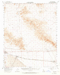
1956 Map of Cadiz
USGS Topo · Published 1964About this map
Bristol Lake and its industrial Salt Evaporators dominate the southern portion of this Mojave Desert landscape, where the Atchison Topeka and Santa Fe railroad tracks parallel a corridor of Pipelines and desert settlements. Small rail stops and outposts like Amboy, Saltus, Chambless, and Cadiz anchor the transportation network through the arid basin. The map reveals a land defined by extraction and passage, from the Oil Tanks near the rail line to the isolated mining operations tucked into the surrounding heights.
Find a feature on this map
38 named features on this map. Tap any name to fly to it.
Don’t see what you’re looking for? This feature index may not catch every label — zoom into the map to look around manually.
Map Details
Editions of this 1956 Cadiz Map
3 editions found

Other maps of this area

1942 · Amboy
USGS Topo · 1:250,000

1943 · Amboy
USGS Topo · 1:250,000

1943 · Danby
USGS Topo · 1:62,500

1943 · Cadiz Lake
USGS Topo · 1:62,500

1954 · Needles
USGS Topo · 1:250,000

1954 · Bristol Lake NW
USGS Topo · 1:24,000

1954 · Amboy Crater
USGS Topo · 1:24,000

1955 · Lead Mtn. NE
USGS Topo · 1:24,000

1955 · Lead Mountain
USGS Topo · 1:62,500

1956 · Needles
USGS Topo · 1:250,000