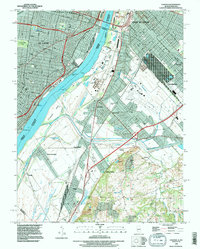
1993 Map of Cahokia
USGS Topo · Published 1996About this map
The Mississippi River serves as the central artery dividing the dense urban grids of St Louis, Missouri, from the industrial corridors and residential pockets of Illinois. This 1993 revision, based on surveys dating back to 1929, illustrates the complex infrastructure of East St Louis and Cahokia. Notable for its genealogical value, the map identifies local landmarks such as Holy Family Cem and the Bohnemeier Cem. The landscape transitions from the historic Lafayette Park and Tower Grove Park in the west to the quarrying operations near Falling Spring and the rail-heavy environment of Dupo. Large-scale features like Arsenal Island and Dead Creek highlight the persistent influence of the river geography on the regional development of St. Clair County.
Find a feature on this map
43 named features on this map. Tap any name to fly to it.
Don’t see what you’re looking for? This feature index may not catch every label — zoom into the map to look around manually.
Map Details
Editions of this 1993 Cahokia Map
This is the sole edition of this map. No revisions or reprints were ever made.
Other maps of this area

1888 · St. Louis
USGS Topo · 1:62,500

1910 · Waterloo
USGS Topo · 1:62,500

1912 · Kimmswick
USGS Topo · 1:62,500

1913 · Waterloo
USGS Topo · 1:62,500

1916 · Kimmswick
USGS Topo · 1:62,500

1931 · French Village
USGS Topo · 1:24,000

1933 · Granite City
USGS Topo · 1:24,000

1933 · Jefferson Barracks
USGS Topo · 1:24,000

1933 · Cahokia
USGS Topo · 1:24,000

1933 · Clayton
USGS Topo · 1:24,000