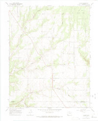
1965 Map of Cahone
USGS Topo · Published 1984About this map
The settlement of Cahone sits on a high plateau in the mid-1960s, serving as a focal point for rural life along the boundary between Dolores and Montezuma Counties. This map shows a landscape defined by its community landmarks and the deep incisions of the surrounding canyon systems. Local social geography is anchored by the Cahone Ch, Cahone Sch, and a nearby Cem, which reflect the localized nature of the population before significant modern expansion.
Find a feature on this map
15 named features on this map. Tap any name to fly to it.
Don’t see what you’re looking for? This feature index may not catch every label — zoom into the map to look around manually.
Map Details
Editions of this 1965 Cahone Map
2 editions found
Other maps of this area

1956 · Cortez
USGS Topo · 1:250,000

1957 · Cedar 3 NW
USGS Topo · 1:24,000

1957 · Cedar 3 SW
USGS Topo · 1:24,000

1958 · Cortez
USGS Topo · 1:250,000

1959 · Cortez
USGS Topo · 1:250,000

1962 · Cortez
USGS Topo · 1:250,000
1964 · Secret Canyon
USGS Topo · 1:24,000

1964 · The Glade
USGS Topo · 1:24,000
1964 · Dove Creek
USGS Topo · 1:24,000

1965 · Cahone
USGS Topo · 1:24,000