
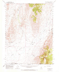
1961 Map of Cain Mountain
USGS Topo · Published 1963About this map
Augusta Mountains and the Tobiyabe Range dominate this high-desert basin-and-range landscape, where water dictates the location of early ranching outposts. This early 1960s survey records the isolated geography of Jersey Valley, Dixie Valley, and Pleasant Valley, linked by a network of unimproved roads and a Jeep Trail. Thermal activity is a defining characteristic of the area, evidenced by Sou Hot Springs in the Sou Hills and several other unnamed springs that supported remote operations like Seven Devils Ranch and Little McCoy Ranch. Far from any major highway, the map reveals a quiet era of Great Basin life where airway beacons and cattle stations were the primary landmarks. The presence of Home Station Ranch near Home Station Wash and the McCoy Well further underscores the sparse but strategic human presence in these desolate valleys.
Find a feature on this map
29 named features on this map. Tap any name to fly to it.
Don’t see what you’re looking for? This feature index may not catch every label — zoom into the map to look around manually.
Map Details
Editions of this 1961 Cain Mountain Map
2 editions found
Other maps of this area

1932 · Sonoma Range
USGS Topo · 1:250,000

1939 · Sonoma Range
USGS Topo · 1:250,000

1955 · Millett
USGS Topo · 1:250,000

1955 · Winnemucca
USGS Topo · 1:250,000

1958 · Winnemucca
USGS Topo · 1:250,000

1959 · Millett
USGS Topo · 1:250,000
1961 · Kyle Hot Springs
USGS Topo · 1:62,500

1961 · Mt. Tobin
USGS Topo · 1:62,500

1961 · Fencemaker
USGS Topo · 1:62,500

1961 · Mt. Moses
USGS Topo · 1:62,500