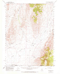
1961 Map of Cain Mountain
USGS Topo · Published 1968About this map
Dixie Valley and Jersey Valley dominate this Great Basin landscape, where the high peaks of the Tobin Range and the Augusta Mountains flank desert basins. The mapping records a critical geological record in Scarp 1915, marking the visible surface rupture of a significant historical earthquake. Water is the primary driver of settlement here, with isolated outposts like Home Station Ranch and Seven Devils Ranch positioned near vital water sources. Geothermal activity is a defining feature of the area, evidenced by Hyder Hot Springs and Sou Hot Springs. A network of Jeep Trails provides the only access through the basins, connecting remote cattle operations to the outside world across the Pershing and Churchill County line.
Find a feature on this map
32 named features on this map. Tap any name to fly to it.
Don’t see what you’re looking for? This feature index may not catch every label — zoom into the map to look around manually.
Map Details
Editions of this 1961 Cain Mountain Map
2 editions found
Other maps of this area

1932 · Sonoma Range
USGS Topo · 1:250,000

1939 · Sonoma Range
USGS Topo · 1:250,000

1955 · Millett
USGS Topo · 1:250,000

1955 · Winnemucca
USGS Topo · 1:250,000

1958 · Winnemucca
USGS Topo · 1:250,000

1959 · Millett
USGS Topo · 1:250,000
1961 · Kyle Hot Springs
USGS Topo · 1:62,500

1961 · Mt. Tobin
USGS Topo · 1:62,500

1961 · Cain Mountain
USGS Topo · 1:62,500

1961 · Fencemaker
USGS Topo · 1:62,500