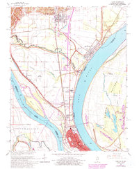
1967 Map of Cairo
USGS Topo · Published 1978About this map
The confluence of the Ohio River and Mississippi River anchors this geographic study, where the massive water bodies meet south of the city of Cairo. The landscape is defined by the high levee systems protecting the lowland settlements of Future City and Urbandale. The industrial and transportation identity of the region is evident in the convergence of the Illinois Central Gulf, Illinois Central, and Missouri Pacific railroads.
Find a feature on this map
61 named features on this map. Tap any name to fly to it.
Don’t see what you’re looking for? This feature index may not catch every label — zoom into the map to look around manually.
Map Details
Editions of this 1967 Cairo Map
3 editions found
Other maps of this area

1931 · Cairo
USGS Topo · 1:62,500

1933 · Cairo
USGS Topo · 1:62,500

1934 · Thebes
USGS Topo · 1:62,500

1939 · Wickliffe
USGS Topo · 1:62,500

1939 · Charleston
USGS Topo · 1:62,500

1939 · Cairo
USGS Topo · 1:62,500

1939 · Thebes
USGS Topo · 1:62,500

1949 · Paducah
USGS Topo · 1:250,000

1950 · Paducah
USGS Topo · 1:250,000

1951 · Wickliffe
USGS Topo · 1:24,000