
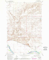
1950 Map of Calais
USGS Topo · Published 1952About this map
The Fort Peck Indian Reservation dominates this northeastern Montana landscape, where the high plains meet the valley of the Missouri River. Following the river's northern bank, the Great Northern railroad provides the primary transportation artery, passing through the small settlement of Calais. The survey reveals a landscape shaped by both natural watercourses and human industry, with the winding paths of Box Elder Creek and Elder Creek carving through the terrain north of the rail line. Evidence of local extraction is found at the Alton Mine and a Gravel Pit near the reservation boundary. The map captures the transition from the upland coulees to the fertile river bottom, illustrating how early 20th-century commerce and infrastructure aligned with the region's physical geography.
Find a feature on this map
14 named features on this map. Tap any name to fly to it.
Don’t see what you’re looking for? This feature index may not catch every label — zoom into the map to look around manually.
Map Details
Editions of this 1950 Calais Map
2 editions found
Other maps of this area

1909 · Smoke Creek
USGS Topo · 1:62,500

1912 · Smoke Creek
USGS Topo · 1:62,500

1914 · Brockton
USGS Topo · 1:62,500

1914 · Homestead
USGS Topo · 1:62,500

1947 · Rocky Point
USGS Topo · 1:24,000

1948 · Rocky Point
USGS Topo · 1:24,000

1948 · Fort Kipp
USGS Topo · 1:24,000

1949 · Fort Kipp
USGS Topo · 1:24,000

1950 · Coyote Coulee
USGS Topo · 1:24,000

1954 · Wolf Point
USGS Topo · 1:250,000
Featured Places
- Brockton District, MT
- Fort Kipp District, MT
- Calais, Fort Kipp District
- Richland County, MT
- Roosevelt County, MT