
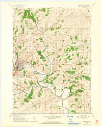
1952 Map of Calamine
USGS Topo · Published 1954About this map
Pecatonica River winding through the driftless area of Lafayette County defines the landscape of this early 1950s survey. The village of Calamine serves as a local hub at the confluence of several watercourses, including Bonner Branch and Wood Branch. The region's agricultural and social fabric is clearly visible through a dense network of country schools and family-centered landmarks, such as Hamestreet Sch, Meylor Sch, and Truman Sch.
Find a feature on this map
39 named features on this map. Tap any name to fly to it.
Don’t see what you’re looking for? This feature index may not catch every label — zoom into the map to look around manually.
Map Details
Editions of this 1952 Calamine Map
This is the sole edition of this map. No revisions or reprints were ever made.
Other maps of this area

1902 · Mineral Point
USGS Topo · 1:125,000

1952 · Shullsburg
USGS Topo · 1:24,000

1952 · Mineral Point
USGS Topo · 1:24,000

1952 · Belmont
USGS Topo · 1:24,000

1952 · New Diggings
USGS Topo · 1:24,000

1952 · Mifflin
USGS Topo · 1:24,000

1959 · Dubuque
USGS Topo · 1:250,000

1961 · Dubuque
USGS Topo · 1:250,000

1962 · Dubuque
USGS Topo · 1:250,000
1962 · Darlington
USGS Topo · 1:24,000