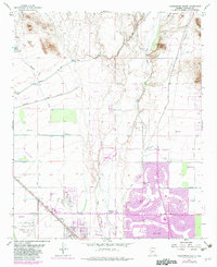
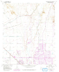
1957 Map of Calderwood Butte
USGS Topo · Published 1982About this map
The Agua Fria River corridor in Maricopa County reveals a landscape in rapid transition, where ancient sites meet modern suburban expansion. While Indian Ruins and Petroglyphs near Calderwood Butte speak to a deep indigenous history, the 1980s-era revisions captured in purple show the emergence of planned communities like Sun City and Peoria. The agricultural and ranching roots of the region are evidenced by the Atchison Topeka and Santa Fe railroad line passing through Lizard Acres, a name reflecting the area's arid character before large-scale irrigation and residential development.
Find a feature on this map
36 named features on this map. Tap any name to fly to it.
Don’t see what you’re looking for? This feature index may not catch every label — zoom into the map to look around manually.
Map Details
Editions of this 1957 Calderwood Butte Map
6 editions found
Other maps of this area

1954 · Phoenix
USGS Topo · 1:250,000

1957 · Phoenix
USGS Topo · 1:250,000

1957 · Calderwood Butte
USGS Topo · 1:24,000

1957 · McMicken Dam
USGS Topo · 1:24,000

1957 · El Mirage
USGS Topo · 1:24,000

1957 · Waddell
USGS Topo · 1:24,000

1957 · Hedgpeth Hills
USGS Topo · 1:24,000

1957 · Glendale
USGS Topo · 1:24,000

1958 · Phoenix
USGS Topo · 1:250,000

1960 · Phoenix
USGS Topo · 1:250,000