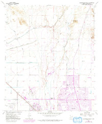
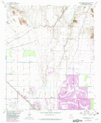
1957 Map of Calderwood Butte
USGS Topo · Published 1992About this map
Lizard Acres and Surprise sit at the center of this 1957 survey, which documents a pivotal era of suburban expansion and desert engineering. The landscape is defined by the Agua Fria River and an extensive irrigation network including the Beardsley Canal and Marinette Canal, which transformed the arid valley floor for agricultural and residential use. The map captures the early footprints of Sun City and Peoria, marked by the circular street patterns that would become iconic of the region's mid-century growth.
Find a feature on this map
32 named features on this map. Tap any name to fly to it.
Don’t see what you’re looking for? This feature index may not catch every label — zoom into the map to look around manually.
Map Details
Editions of this 1957 Calderwood Butte Map
6 editions found
Other maps of this area

1954 · Phoenix
USGS Topo · 1:250,000

1957 · Phoenix
USGS Topo · 1:250,000

1957 · Calderwood Butte
USGS Topo · 1:24,000

1957 · McMicken Dam
USGS Topo · 1:24,000

1957 · El Mirage
USGS Topo · 1:24,000

1957 · Waddell
USGS Topo · 1:24,000

1957 · Hedgpeth Hills
USGS Topo · 1:24,000

1957 · Glendale
USGS Topo · 1:24,000

1958 · Phoenix
USGS Topo · 1:250,000

1960 · Phoenix
USGS Topo · 1:250,000