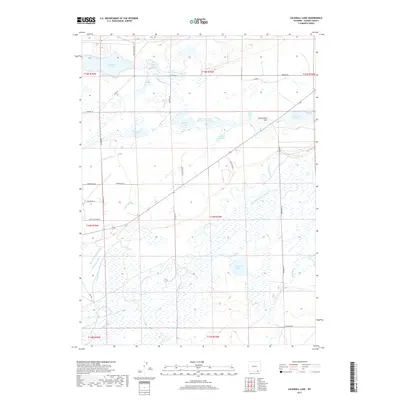
2017 Map of Caldwell Lake
USGS Topo · Published 2017About this map
The Laramie River meanders across this high plains landscape of Albany County, defining a complex network of agricultural irrigation and water storage. This 2017 U.S. Geological Survey record reveals an intricate system of water management where the Lake Hattie Canal and Riverside Ditch Number 1 support local ranching. Notable water bodies such as Twin Buttes Lake, Gelatt Lake, and Caldwell Lake punctuate the terrain, many linked by historic channels like the Bush and Holliday Ditch. The presence of the Soda Lake Draw Number 1 Reservoir and Harman Reservoir further illustrates the engineered nature of the regional hydrology. Local landforms like Twelvemile Hill rise above the basin, while family-named roads such as Pahlow Ln, Meeboer Rd, and Brubaker Ln provide evidence of long-standing rural settlement and land use patterns.
Find a feature on this map
51 named features on this map. Tap any name to fly to it.
Don’t see what you’re looking for? This feature index may not catch every label — zoom into the map to look around manually.
Map Details
Editions of this 2017 Caldwell Lake Map
This is the sole edition of this map. No revisions or reprints were ever made.
Other maps of this area

1895 · Laramie
USGS Topo · 1:125,000

1902 · Laramie
USGS Topo · 1:125,000

1905 · Laramie
USGS Topo · 1:125,000

1906 · Laramie
USGS Topo · 1:125,000

1908 · Laramie
USGS Topo · 1:125,000

1954 · Cheyenne
USGS Topo · 1:250,000

1958 · Cheyenne
USGS Topo · 1:250,000
1962 · Miller
USGS Topo · 1:24,000
1962 · Millbrook
USGS Topo · 1:24,000
1963 · Jelm Mountain
USGS Topo · 1:24,000