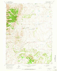
1963 Map of Jelm Mountain
USGS Topo · Published 1965About this map
Jelm Mountain dominates this portion of the Albany County landscape, where the high-altitude topography is defined by prominent peaks and a complex network of seasonal drainage. A Jelm Lookout stands atop the mountain's crest, overlooking the remote Cole Ranch and the deep incisions of Pollock Draw and Cathy Draw. This 1963 field survey reveals a terrain shaped by both natural water sources and human engineering, featuring numerous named springs alongside an Aqueduct and scattered Quarries near the southern slopes.
Find a feature on this map
25 named features on this map. Tap any name to fly to it.
Don’t see what you’re looking for? This feature index may not catch every label — zoom into the map to look around manually.
Map Details
Editions of this 1963 Jelm Mountain Map
3 editions found
Other maps of this area

1895 · Laramie
USGS Topo · 1:125,000

1902 · Laramie
USGS Topo · 1:125,000

1905 · Laramie
USGS Topo · 1:125,000

1906 · Medicine Bow
USGS Topo · 1:125,000

1906 · Laramie
USGS Topo · 1:125,000

1908 · Laramie
USGS Topo · 1:125,000

1908 · Medicine Bow
USGS Topo · 1:125,000

1916 · Home
USGS Topo · 1:125,000

1920 · Home
USGS Topo · 1:125,000

1954 · Cheyenne
USGS Topo · 1:250,000