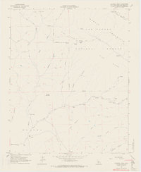
1967 Map of Caldwell Mesa
USGS Topo · Published 1968About this map
Garcia Mountain and the southern ridges of the Los Padres National Forest dominate this mid-century topographic survey of rural San Luis Obispo County. The landscape is defined by the headwaters of the Salinas River in the northeast and the Huasna River to the southwest, separated by a complex network of canyons and high ridges like Pine Ridge. The human presence here is sparse and primarily agricultural, marked by isolated homesteads and ranching outposts connected by a lattice of primitive paths including the Pack Trail and various Jeep Trails. Researchers will find significant genealogical value in the naming of specific family holdings and structures, such as Hathaway Place, Venados Ranch, and Records Ranch, which highlight the persistence of high-country ranching life. Landmark features like Bonnet Rock and the flat-topped Caldwell Mesa provide distinct navigational points within the difficult terrain of Huasna.
Find a feature on this map
36 named features on this map. Tap any name to fly to it.
Don’t see what you’re looking for? This feature index may not catch every label — zoom into the map to look around manually.
Map Details
Editions of this 1967 Caldwell Mesa Map
3 editions found
Other maps of this area

1922 · Pozo
USGS Topo · 1:62,500

1922 · Nipomo
USGS Topo · 1:62,500

1932 · La Panza
USGS Topo · 1:48,000

1935 · La Panza
USGS Topo · 1:62,500

1936 · La Panza
USGS Topo · 1:62,500

1937 · Branch Mtn
USGS Topo · 1:48,000

1942 · Branch Mountain
USGS Topo · 1:62,500

1947 · San Luis Obispo
USGS Topo · 1:250,000

1948 · San Luis Obispo
USGS Topo · 1:250,000
1952 · La Panza
USGS Topo · 1:62,500