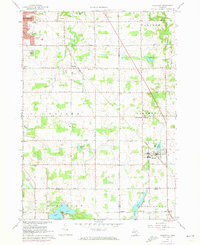
1967 Map of Caledonia
USGS Topo · Published 1973About this map
The Penn Central railroad corridor bisects this landscape, connecting the established community of Caledonia with the developing corporate limits of Kentwood. This mid-century survey reveals a transition from the structured residential blocks and schools of the village centers to the broader agricultural lands of Gaines and Thornapple townships. The map records several vital community hubs, including Holy Corners and numerous rural houses of worship like St Pauls Ch and St Josephs Ch.
Find a feature on this map
53 named features on this map. Tap any name to fly to it.
Don’t see what you’re looking for? This feature index may not catch every label — zoom into the map to look around manually.
Map Details
Editions of this 1967 Caledonia Map
3 editions found
Other maps of this area

1914 · Grand Rapids
USGS Topo · 1:62,500

1918 · Lowell
USGS Topo · 1:62,500

1943 · Grand Rapids
USGS Topo · 1:62,500

1943 · Lowell
USGS Topo · 1:62,500

1951 · Hastings
USGS Topo · 1:62,500

1958 · Grand Rapids
USGS Topo · 1:250,000

1959 · Wayland
USGS Topo · 1:62,500

1961 · Grand Rapids
USGS Topo · 1:250,000

1962 · Grand Rapids
USGS Topo · 1:250,000
1967 · Grand Rapids West
USGS Topo · 1:24,000
Featured Places
- Kentwood, MI
- Gaines Charter Township, MI
- Cascade Charter Township, MI
- Caledonia, MI
- Dutton, Gaines Charter Township