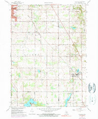
1967 Map of Caledonia
USGS Topo · Published 1973About this map
Caledonia and the surrounding townships of Gaines, Cascade, and Thornapple are captured here during a period of transition as the Grand Rapids suburbs began to push south. The Penn Central rail line cuts diagonally across the landscape, serving as a primary corridor through Dutton and past the site of Holy Corners. This era reveals a mix of established rural infrastructure and emerging residential growth, with several local schools like Gaines Sch and Dutton Sch still central to their respective communities.
Find a feature on this map
58 named features on this map. Tap any name to fly to it.
Don’t see what you’re looking for? This feature index may not catch every label — zoom into the map to look around manually.
Map Details
Editions of this 1967 Caledonia Map
3 editions found
Other maps of this area

1914 · Grand Rapids
USGS Topo · 1:62,500

1918 · Lowell
USGS Topo · 1:62,500

1943 · Grand Rapids
USGS Topo · 1:62,500

1943 · Lowell
USGS Topo · 1:62,500

1951 · Hastings
USGS Topo · 1:62,500

1958 · Grand Rapids
USGS Topo · 1:250,000

1959 · Wayland
USGS Topo · 1:62,500

1961 · Grand Rapids
USGS Topo · 1:250,000

1962 · Grand Rapids
USGS Topo · 1:250,000
1967 · Grand Rapids West
USGS Topo · 1:24,000
Featured Places
- Kentwood, MI
- Gaines Charter Township, MI
- Cascade Charter Township, MI
- Caledonia, MI
- Dutton, Gaines Charter Township