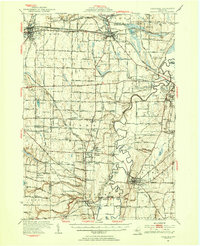
1951 Map of Caledonia
USGS Topo · Published 1956About this map
Genesee River meanders through this mid-century landscape, carving a wide valley that serves as the industrial and academic heart of Livingston Co. In Geneseo, the State Teachers College and the Armory anchor the village, while to the west, the massive Salt Mine at Retsof highlights the region's deep mineral resources. This extraction economy is supported by a dense web of rail lines, including the Genesee and Wyoming River and the Lackawanna R.R., which navigate the terrain alongside local landmarks like Hemp Pond and Beards Creek.
Find a feature on this map
73 named features on this map. Tap any name to fly to it.
Don’t see what you’re looking for? This feature index may not catch every label — zoom into the map to look around manually.
Map Details
Editions of this 1951 Caledonia Map
2 editions found
Other maps of this area

1895 · Rochester
USGS Topo · 1:62,500

1897 · Albion
USGS Topo · 1:62,500

1898 · Rochester
USGS Topo · 1:62,500

1899 · Brockport
USGS Topo · 1:62,500

1901 · Honeoye
USGS Topo · 1:62,500

1902 · Wayland
USGS Topo · 1:62,500

1904 · Wayland
USGS Topo · 1:62,500

1904 · Batavia
USGS Topo · 1:62,500

1904 · Caledonia
USGS Topo · 1:62,500

1904 · Honeoye
USGS Topo · 1:62,500