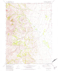
1971 Map of California Mtn.
USGS Topo · Published 1982About this map
The Humboldt National Forest encompasses this high-elevation landscape, dominated by the peaks of Independence Mountain and California Mountain. This 1971 field-checked survey reveals a remote ranching and prospecting territory where the Independence Mountains shed water through numerous drainages such as Pratt Creek and Foreman Creek. The presence of a Prospect near the head of Stump Creek and a network of jeep trails through Jerritt Canyon indicates the area's ongoing mineral interest during the late 20th century. Lowland activity is concentrated at family operations like Evans Ranch and Jose Ranch, which relied on the complex watershed of the North Fork Pratt Creek and Middle Fork Foreman Creek. The map serves as a vital record of land use in Elko County before larger-scale modern industrial mining significantly altered the local topography.
Find a feature on this map
20 named features on this map. Tap any name to fly to it.
Don’t see what you’re looking for? This feature index may not catch every label — zoom into the map to look around manually.
Map Details
Editions of this 1971 California Mtn. Map
3 editions found

Other maps of this area

1955 · McDermitt
USGS Topo · 1:250,000

1955 · Wells
USGS Topo · 1:250,000

1956 · Tuscarora
USGS Topo · 1:62,500

1956 · Bull Run
USGS Topo · 1:62,500

1956 · Wild Horse
USGS Topo · 1:62,500

1958 · Wells
USGS Topo · 1:250,000

1959 · McDermitt
USGS Topo · 1:250,000

1961 · Wells
USGS Topo · 1:250,000

1971 · Mahala Creek West
USGS Topo · 1:24,000

1971 · North Fork
USGS Topo · 1:24,000