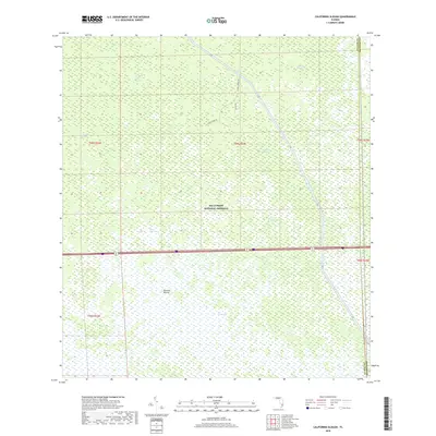
2018 Map of California Slough
USGS Topo · Published 2018About this map
Big Cypress National Preserve dominates this 2018 survey, documenting a wilderness of hydrologic features and subtle terrain variations within The Everglades. The landscape is defined by its strands and prairies, such as Goddens Strand, Cow Bell Strand, and Doctors Prairie. This quadrangle illustrates the massive scale of regional water management, centered on the Interceptor Canal and the L-28 levee and canal system, which cuts a straight path through the wetland. Human presence is limited to a few arterial routes like Otter Creek Rd and Big Cypress Rd. This map captures the intersection of conservation and engineering, where water bodies like Tarpan Lake and the eponymous California Slough exist alongside the rigid lines of the Florida canal network on the border of Collier and Broward counties.
Find a feature on this map
20 named features on this map. Tap any name to fly to it.
Don’t see what you’re looking for? This feature index may not catch every label — zoom into the map to look around manually.
Map Details
Editions of this 2018 California Slough Map
This is the sole edition of this map. No revisions or reprints were ever made.
Other maps of this area

1956 · West Palm Beach
USGS Topo · 1:250,000

1957 · West Palm Beach
USGS Topo · 1:250,000

1958 · West Palm Beach
USGS Topo · 1:250,000

1973 · Everglades 3 NE
USGS Topo · 1:24,000

1974 · Everglades 2 SW
USGS Topo · 1:24,000

1974 · Immokalee 1 SE
USGS Topo · 1:24,000

1974 · Everglades 2 SE
USGS Topo · 1:24,000
1974 · Everglades 3 SW
USGS Topo · 1:24,000
1974 · Immokalee 4 NE
USGS Topo · 1:24,000
1974 · Everglades 3 NW
USGS Topo · 1:24,000