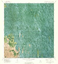
1974 Map of Everglades 3 SW
USGS Topo · Published 1976About this map
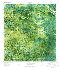
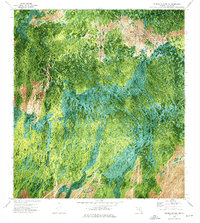
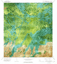
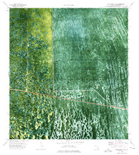
The Florida State Miccosukee Indian Reservation occupies the northeastern corner of this 1974 orthophotomap, showing a complex mosaic of sawgrass prairies and tree islands. This specific survey, prepared from 1971 aerial photography, provides a rare visual record of the undeveloped Everglades interior along the boundary between Collier Co and Broward Co. The high-resolution imagery reveals the distinct textures of the wetlands, where subtle variations in elevation create the archipelago of hammocks that define the Miccosukee tribal lands. Free from major roads or modern infrastructure, the map preserves the state of the wilderness before later water management projects further altered the natural sheet-flow patterns of the region.
Find a feature on this map
4 named features on this map. Tap any name to fly to it.
Don’t see what you’re looking for? This feature index may not catch every label — zoom into the map to look around manually.
Map Details
Editions of this 1974 Everglades 3 SW Map
2 editions found

Other maps of this area

1956 · Miami
USGS Topo · 1:250,000

1956 · West Palm Beach
USGS Topo · 1:250,000

1957 · West Palm Beach
USGS Topo · 1:250,000

1958 · West Palm Beach
USGS Topo · 1:250,000

1958 · Miami
USGS Topo · 1:250,000
1972 · Monroe Station NE
USGS Topo · 1:24,000
1973 · North Of Fiftymile Bend
USGS Topo · 1:24,000
1973 · Everglades 3 NE
USGS Topo · 1:24,000
1973 · North of Fortymile Bend
USGS Topo · 1:24,000
1974 · Immokalee 4 NE
USGS Topo · 1:24,000