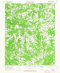
1965 Map of Callands
USGS Topo · Published 1966About this map
Callands and its surrounding rural hamlets are detailed in this mid-1960s study of Pittsylvania County, showing a landscape defined by its numerous small churches and family-named cemeteries. The terrain is marked by Brier Mountain and a dense network of watercourses, including the Banister River and Wet Sleeve Creek. Notable local landmarks such as Hollys Mill and the Union Hall Sch indicate the community's established social infrastructure, while the Cherrystone Youth Camp serves as a distinct recreational node near Mitchell Branch.
Find a feature on this map
34 named features on this map. Tap any name to fly to it.
Don’t see what you’re looking for? This feature index may not catch every label — zoom into the map to look around manually.
Map Details
Editions of this 1965 Callands Map
3 editions found
Other maps of this area

1921 · Chatham
USGS Topo · 1:48,000

1922 · Callands
USGS Topo · 1:48,000

1923 · Danville
USGS Topo · 1:48,000

1923 · Chatham
USGS Topo · 1:62,500

1924 · Draper
USGS Topo · 1:48,000

1924 · Callands
USGS Topo · 1:62,500

1925 · Danville
USGS Topo · 1:62,500

1926 · Draper
USGS Topo · 1:62,500

1944 · Draper
USGS Topo · 1:62,500

1944 · Callands
USGS Topo · 1:62,500