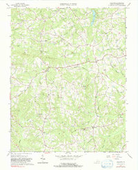
1965 Map of Callands
USGS Topo · Published 1991About this map
Hollys Mill stands along the Sandy River in this mid-1960s study of central Pittsylvania County, where the landscape is defined by the winding drainages of the Banister River and Wet Sleeve Creek. The mapping reveals a rural social infrastructure centered on small communities like Callands and Worlds, supported by numerous local institutions such as the Christian Tabernacle and Union Hall Sch. The presence of the Oak Ridge Ch Sch and Cherrystone Youth Camp suggests the enduring importance of communal and educational hubs in these rolling highlands.
Find a feature on this map
34 named features on this map. Tap any name to fly to it.
Don’t see what you’re looking for? This feature index may not catch every label — zoom into the map to look around manually.
Map Details
Editions of this 1965 Callands Map
3 editions found
Other maps of this area

1921 · Chatham
USGS Topo · 1:48,000

1922 · Callands
USGS Topo · 1:48,000

1923 · Danville
USGS Topo · 1:48,000

1923 · Chatham
USGS Topo · 1:62,500

1924 · Draper
USGS Topo · 1:48,000

1924 · Callands
USGS Topo · 1:62,500

1925 · Danville
USGS Topo · 1:62,500

1926 · Draper
USGS Topo · 1:62,500

1944 · Draper
USGS Topo · 1:62,500

1944 · Callands
USGS Topo · 1:62,500