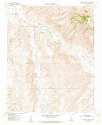
1961 Map of Camatta Canyon
USGS Topo · Published 1962About this map
Camatta Canyon and the surrounding eastern San Luis Obispo County landscape are defined by an intricate network of drainage systems and agricultural outposts in this early 1960s study. The broad valley of San Juan Creek serves as a central artery for the region, flanked by the steep rising elevations of the Temblor Range and the distinctive Red Hills to the northeast. Small-scale ranching operations like Alfalfa Ranch and Canyon Ranch appear as primary nodes of human activity, connected by unpaved corridors such as Truesdale Road and numerous unnamed jeep trails. The map illustrates a transitional landscape where high-desert canyons like Slocum Canyon and Tin Pan meet the seasonal watercourses of the valley floor, highlighting the importance of water management and topography in 20th-century California ranching life.
Find a feature on this map
20 named features on this map. Tap any name to fly to it.
Don’t see what you’re looking for? This feature index may not catch every label — zoom into the map to look around manually.
Map Details
Editions of this 1961 Camatta Canyon Map
3 editions found
Other maps of this area

1914 · Cholame
USGS Topo · 1:125,000

1915 · Cholame
USGS Topo · 1:125,000

1917 · Cholame
USGS Topo · 1:125,000

1922 · Pozo
USGS Topo · 1:62,500

1932 · La Panza
USGS Topo · 1:48,000

1935 · La Panza
USGS Topo · 1:62,500

1936 · La Panza
USGS Topo · 1:62,500

1943 · Grant Lake
USGS Topo · 1:31,680

1943 · Shandon
USGS Topo · 1:31,680

1943 · Commatti Canyon
USGS Topo · 1:31,680