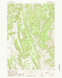
1984 Map of Cambria
USGS Topo · Published 1984About this map
Cambria sits at the heart of this dissected plateau landscape in Weston County, where deep drainages like Cambria Canyon and Camp Creek carve through the high plains. The terrain is defined by prominent upland features such as Jumbo Table and the sweeping Antelope Flats, which are flanked by notable high points including Mount Pisgah to the northeast and Breakneck Hill.
Find a feature on this map
25 named features on this map. Tap any name to fly to it.
Don’t see what you’re looking for? This feature index may not catch every label — zoom into the map to look around manually.
Map Details
Editions of this 1984 Cambria Map
This is the sole edition of this map. No revisions or reprints were ever made.
Other maps of this area

1898 · Sundance
USGS Topo · 1:125,000

1899 · Newcastle
USGS Topo · 1:125,000

1901 · Newcastle
USGS Topo · 1:125,000

1902 · Sundance
USGS Topo · 1:125,000

1951 · Newcastle
USGS Topo · 1:24,000

1951 · Fanny Peak
USGS Topo · 1:24,000

1951 · Osage SE
USGS Topo · 1:24,000

1954 · Gillette
USGS Topo · 1:250,000

1955 · Newcastle
USGS Topo · 1:250,000

1955 · Gillette
USGS Topo · 1:250,000