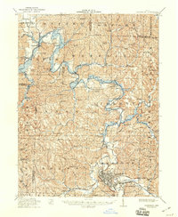
1912 Map of Cambridge
USGS Topo · Published 1946About this map
Cambridge serves as the industrial and transportation hub of this eastern Ohio landscape, where the National Road and the Baltimore and Ohio RR intersect. The topography is defined by the winding course of Wills Creek and its many tributaries, such as Leatherwood Creek and Birds Run. The settlement pattern reflects a deeply established rural community, with a high density of named schools like Independence School and Slaughter Hill School serving scattered hilltop farms and valley hamlets.
Find a feature on this map
103 named features on this map. Tap any name to fly to it.
Don’t see what you’re looking for? This feature index may not catch every label — zoom into the map to look around manually.
Map Details
Editions of this 1912 Cambridge Map
2 editions found

Other maps of this area

1908 · Conesville
USGS Topo · 1:62,500

1909 · Antrim
USGS Topo · 1:48,000

1909 · Uhrichsville
USGS Topo · 1:62,500

1909 · Summerfield
USGS Topo · 1:62,500

1909 · Cambridge
USGS Topo · 1:62,500

1910 · Philo
USGS Topo · 1:62,500

1910 · Conesville
USGS Topo · 1:62,500

1911 · Antrim
USGS Topo · 1:62,500

1911 · Uhrichsville
USGS Topo · 1:62,500

1911 · Cumberland
USGS Topo · 1:62,500