
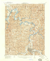
1912 Map of Cambridge
USGS Topo · Published 1946About this map
The National Road cuts a historic path through the southern hills of Guernsey County, providing the primary east-west artery for Cambridge. This landscape is defined by the winding course of Wills Creek, which feeds a large Reservoir near Kimbolton. The region exhibits a dense network of nineteenth-century rural infrastructure, where local life revolved around numerous small district schools like Partridge Trapp School and Science Hill School. Industrial activity is evident along the Baltimore and Ohio RR and Pennsylvania System rail lines, which intersect near the city center.
Find a feature on this map
94 named features on this map. Tap any name to fly to it.
Don’t see what you’re looking for? This feature index may not catch every label — zoom into the map to look around manually.
Map Details
Editions of this 1912 Cambridge Map
2 editions found
Other maps of this area

1908 · Conesville
USGS Topo · 1:62,500

1909 · Antrim
USGS Topo · 1:48,000

1909 · Uhrichsville
USGS Topo · 1:62,500

1909 · Summerfield
USGS Topo · 1:62,500

1909 · Cambridge
USGS Topo · 1:62,500

1910 · Philo
USGS Topo · 1:62,500

1910 · Conesville
USGS Topo · 1:62,500

1911 · Antrim
USGS Topo · 1:62,500

1911 · Uhrichsville
USGS Topo · 1:62,500

1911 · Cumberland
USGS Topo · 1:62,500