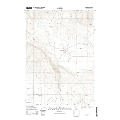
2013 Map of Cambridge
USGS Topo · Published 2013About this map
The Weiser River valley forms the central axis of this landscape, where the settlement of Cambridge sits at the confluence of several vital waterways. This 2013 survey illustrates a geographic transition from the agricultural lowlands of the Salubria Valley to the more confined Shoe Peg Valley in the south. The layout of the town, including Railroad St, reflects its historical development as a shipping point within this ranching and farming district.
Find a feature on this map
47 named features on this map. Tap any name to fly to it.
Don’t see what you’re looking for? This feature index may not catch every label — zoom into the map to look around manually.
Map Details
Editions of this 2013 Cambridge Map
This is the sole edition of this map. No revisions or reprints were ever made.
Other maps of this area

1897 · Weiser
USGS Topo · 1:125,000

1953 · Mann Creek
USGS Topo · 1:62,500

1955 · Baker
USGS Topo · 1:250,000

1957 · Cambridge
USGS Topo · 1:62,500

1957 · Crane Creek Reservoir
USGS Topo · 1:62,500

1957 · Sturgill Peak
USGS Topo · 1:62,500

1959 · Baker
USGS Topo · 1:250,000

1980 · McCall
USGS Topo · 1:100,000

1980 · Weiser
USGS Topo · 1:100,000
1986 · East of Cambridge
USGS Topo · 1:24,000