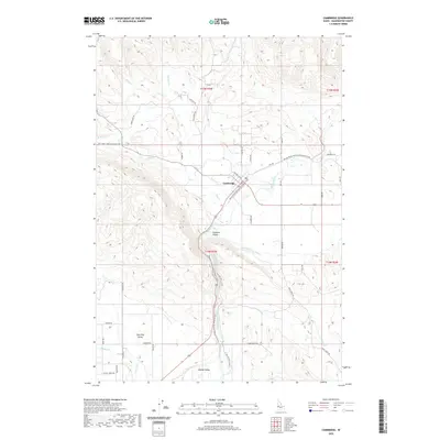
2020 Map of Cambridge
USGS Topo · Published 2020About this map
Cambridge serves as the focal point of this southwestern Idaho landscape, situated where the Weiser River meets its tributaries. The settlement is flanked by distinct geographic depressions, including the Salubria Valley to the south and the broader Middle Valley further downriver. This 2020 survey illustrates a region defined by its hydrography and agricultural infrastructure, where the Middle Valley Ditch and natural courses like the Little Weiser River support the valley floors. A significant modern transformation of the landscape is visible in the Weiser River National Recreation Trail, which follows the historic railroad grade through the valley. Local history is etched into the road network, with names such as Cemetery Rd, Stage Coach Rd, and Old Hwy Rd tracing the movement of people across the Shoe Peg Valley and surrounding foothills.
Find a feature on this map
47 named features on this map. Tap any name to fly to it.
Don’t see what you’re looking for? This feature index may not catch every label — zoom into the map to look around manually.
Map Details
Editions of this 2020 Cambridge Map
This is the sole edition of this map. No revisions or reprints were ever made.
Other maps of this area

1897 · Weiser
USGS Topo · 1:125,000

1953 · Mann Creek
USGS Topo · 1:62,500

1955 · Baker
USGS Topo · 1:250,000

1957 · Cambridge
USGS Topo · 1:62,500

1957 · Crane Creek Reservoir
USGS Topo · 1:62,500

1957 · Sturgill Peak
USGS Topo · 1:62,500

1959 · Baker
USGS Topo · 1:250,000

1980 · McCall
USGS Topo · 1:100,000

1980 · Weiser
USGS Topo · 1:100,000
1986 · East of Cambridge
USGS Topo · 1:24,000