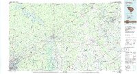
1986 Map of Camden
USGS Topo · Published 1986About this map
Camden serves as the central hub of this mid-1980s landscape, where the Wateree River valley meets the rising topography of the Sandhills. The map reveals a region defined by extensive timberlands and wildlife management, notably within the Carolina Sandhills National Wildlife Refuge and Sandhills State Forest. To the south, the sprawling grounds of Fort Jackson Military Reservation dominate the terrain near Columbia, reflecting the area's long-standing military significance.
Find a feature on this map
139 named features on this map. Tap any name to fly to it.
Don’t see what you’re looking for? This feature index may not catch every label — zoom into the map to look around manually.
Map Details
Editions of this 1986 Camden Map
4 editions found
Other maps of this area

1904 · Columbia
USGS Topo · 1:125,000

1920 · Mayesville
USGS Topo · 1:48,000

1921 · Mayesville
USGS Topo · 1:62,500

1935 · Camden
USGS Topo · 1:48,000

1935 · Killian
USGS Topo · 1:48,000

1937 · Killian
USGS Topo · 1:62,500

1938 · Camden
USGS Topo · 1:62,500

1938 · Hagood
USGS Topo · 1:62,500

1940 · Florence West
USGS Topo · 1:62,500

1941 · Spartanburg
USGS Topo · 1:250,000