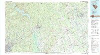
1986 Map of Camden
USGS Topo · Published 1990About this map
Lake Wateree and the Wateree River dominate the western terrain of this mid-1980s survey, marking a landscape defined by significant public and military tracts. The sprawling Fort Jackson Military Reservation occupies the southwestern corner, while the Carolina Sandhills National Wildlife Refuge and Sandhills State Forest cover vast reaches to the northeast. This era shows the established footprint of the Seaboard System railroad connecting commercial hubs like Camden, Bishopville, and Hartsville. Smaller, historic locales such as Lockhart Old Field and Boykin offer a glimpse into the rural settlement patterns of the South Carolina Midlands. Numerous millponds, including Robinson Millpond and Hough Millpond, dot the drainage basins of the Little Lynches River and Black Creek, reflecting a water-rich geography used for both industry and local recreation at Sesquicentennial State Park.
Find a feature on this map
107 named features on this map. Tap any name to fly to it.
Don’t see what you’re looking for? This feature index may not catch every label — zoom into the map to look around manually.
Map Details
Editions of this 1986 Camden Map
4 editions found
Other maps of this area

1904 · Columbia
USGS Topo · 1:125,000

1920 · Mayesville
USGS Topo · 1:48,000

1921 · Mayesville
USGS Topo · 1:62,500

1935 · Camden
USGS Topo · 1:48,000

1935 · Killian
USGS Topo · 1:48,000

1937 · Killian
USGS Topo · 1:62,500

1938 · Camden
USGS Topo · 1:62,500

1938 · Hagood
USGS Topo · 1:62,500

1940 · Florence West
USGS Topo · 1:62,500

1941 · Spartanburg
USGS Topo · 1:250,000