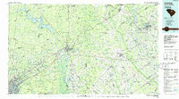
1986 Map of Camden South
USGS Topo · Published 1986About this map
The Wateree River valley and the high, pine-covered ridges of the Sand Hills anchor this 1986 survey of the South Carolina midlands. The historic city of Camden sits at the center of a complex network of water and rail, where the Seaboard System Railroad crosses the river near Hermitage Mill Pond. To the north, the massive Wateree Lake reaches into the hills, while the eastern portion of the map is defined by the agricultural plains around Bishopville and Hartsville.
Find a feature on this map
103 named features on this map. Tap any name to fly to it.
Don’t see what you’re looking for? This feature index may not catch every label — zoom into the map to look around manually.
Map Details
Editions of this 1986 Camden South Map
4 editions found
Other maps of this area

1904 · Columbia
USGS Topo · 1:125,000

1920 · Mayesville
USGS Topo · 1:48,000

1921 · Mayesville
USGS Topo · 1:62,500

1935 · Camden
USGS Topo · 1:48,000

1935 · Killian
USGS Topo · 1:48,000

1937 · Killian
USGS Topo · 1:62,500

1938 · Camden
USGS Topo · 1:62,500

1938 · Hagood
USGS Topo · 1:62,500

1940 · Florence West
USGS Topo · 1:62,500

1941 · Spartanburg
USGS Topo · 1:250,000