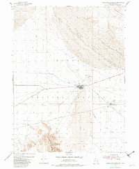
1954 Map of Camels Back Ridge NW
USGS Topo · Published 1980About this map
Dugway Proving Ground military infrastructure dominates this mid-century desert landscape, illustrating the cold war expansion of isolated testing facilities. The map centers on the Dog Area, a concentrated network of buildings and tanks served by a strict grid of military roads including Goodyear Road and Stark Road. To the north and east, vast Sand Dunes sweep toward the base of the Cedar Mts, while Government Creek cuts a narrow path through the arid terrain. The remote outposts of Able Area and Charlie Area are linked by a specialized transportation network, including the Landing Field and several primitive roads like Peter Charlie Road. In the south, the prominent Camels Back Ridge rises abruptly, providing a stark topographical anchor to the otherwise undulating dune fields.
Find a feature on this map
17 named features on this map. Tap any name to fly to it.
Don’t see what you’re looking for? This feature index may not catch every label — zoom into the map to look around manually.
Map Details
Editions of this 1954 Camels Back Ridge NW Map
2 editions found
Other maps of this area

1885 · Tooele Valley
USGS Topo · 1:250,000

1953 · Tooele
USGS Topo · 1:250,000

1954 · Dugway Proving Ground SE
USGS Topo · 1:24,000

1954 · Dugway Proving Ground NE
USGS Topo · 1:24,000

1954 · Camels Back Ridge NW
USGS Topo · 1:24,000

1955 · Tabbys Peak SE
USGS Topo · 1:24,000

1955 · Camels Back Ridge SW
USGS Topo · 1:24,000

1955 · Simpson Springs
USGS Topo · 1:24,000

1955 · Camels Back Ridge NE
USGS Topo · 1:24,000

1955 · Wig Mtn
USGS Topo · 1:24,000