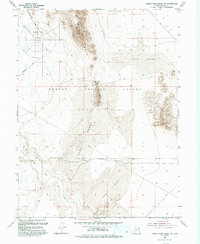
1993 Map of Camels Back Ridge SW
USGS Topo · Published 1993About this map
Dugway Proving Ground (Restricted Area) occupies a significant portion of this desert landscape in Tooele County, representing the intersection of military operations and the arid Great Basin environment. The terrain is defined by the striking geological features of Camels Back Ridge and Simpson Butte, surrounded by expansive areas of shifting Sand Dunes. This region is historically notable for the Old River Bed, a remnant of the prehistoric waterway that once flowed through the Sevier Desert and Bonneville Basin. Human activity in this remote sector is primarily industrial and military, evidenced by the Macintire Road, a remote Prospect, and a Gravel Pit. The map reflects a mid-20th-century landscape updated through the early 1990s, where traditional land uses like mining and early exploration trails meet modern restricted military zones.
Find a feature on this map
11 named features on this map. Tap any name to fly to it.
Don’t see what you’re looking for? This feature index may not catch every label — zoom into the map to look around manually.
Map Details
Editions of this 1993 Camels Back Ridge SW Map
This is the sole edition of this map. No revisions or reprints were ever made.
Other maps of this area

1885 · Sevier Desert
USGS Topo · 1:250,000

1885 · Tooele Valley
USGS Topo · 1:250,000

1908 · Fish Springs
USGS Topo · 1:250,000

1910 · Fish Springs
USGS Topo · 1:250,000

1953 · Dugway Range NE
USGS Topo · 1:24,000

1953 · Dugway Range
USGS Topo · 1:62,500

1953 · Tooele
USGS Topo · 1:250,000

1953 · Delta
USGS Topo · 1:250,000

1954 · Dugway Proving Ground SE
USGS Topo · 1:24,000

1954 · Dugway Proving Ground NE
USGS Topo · 1:24,000