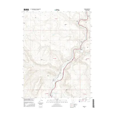
2016 Map of Cameo
USGS Topo · Published 2016About this map
The Colorado River carves a winding path through this western Colorado landscape, creating the dramatic geography of De Beque Canyon. Along its banks, the Government Highline Canal follows the river's contours, representing an essential piece of regional water infrastructure. The settlement of Cameo is situated near the mouth of Coal Canyon, an area historically significant for its eponymous resources, while the Beavertail Mountain Tunnel marks a vital passage through the prominent Beavertail Mountain. High points like Mt Lincoln and Bailey Point overlook a terrain of dissected plateaus and seasonal drainages such as Cottonwood Cr and Asbury Cr. This 2016 survey illustrates the persistent importance of transportation and irrigation corridors in the high desert, from the ancient path of the Cobblestone Trail to modern arterial roads.
Find a feature on this map
41 named features on this map. Tap any name to fly to it.
Don’t see what you’re looking for? This feature index may not catch every label — zoom into the map to look around manually.
Map Details
Editions of this 2016 Cameo Map
This is the sole edition of this map. No revisions or reprints were ever made.
Other maps of this area

1929 · Grand Valley
USGS Topo · 1:62,500

1929 · Roan Creek
USGS Topo · 1:62,500

1955 · Cameo
USGS Topo · 1:24,000

1955 · Mesa
USGS Topo · 1:24,000

1956 · Grand Junction
USGS Topo · 1:250,000

1959 · Grand Junction
USGS Topo · 1:250,000

1960 · Grand Junction
USGS Topo · 1:250,000

1962 · Grand Junction
USGS Topo · 1:250,000

1962 · Clifton
USGS Topo · 1:24,000
1962 · De Beque
USGS Topo · 1:24,000