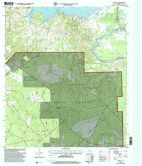
1997 Map of Camilla
USGS Topo · Published 2000About this map
Camilla serves as a central settlement on this late-twentieth-century survey, positioned north of the expansive Sam Houston National Forest. The landscape is defined by the northern reaches of Lake Livingston and the winding Trinity River, which carves through Simon Bottom and forms the sharp Simon Peter Bend. This region maintains a strong connection to its pioneer and rural roots, evidenced by the numerous family-named burial sites such as Milby Hill Cemetery, Cochran Cemetery, and Mitchell Cemetery scattered across the wooded terrain.
Find a feature on this map
43 named features on this map. Tap any name to fly to it.
Don’t see what you’re looking for? This feature index may not catch every label — zoom into the map to look around manually.
Map Details
Editions of this 1997 Camilla Map
This is the sole edition of this map. No revisions or reprints were ever made.
Other maps of this area

1943 · Liberty
USGS Topo · 1:125,000

1954 · Beaumont
USGS Topo · 1:250,000

1955 · Rayburn
USGS Topo · 1:62,500

1957 · Beaumont
USGS Topo · 1:250,000

1958 · Westcott
USGS Topo · 1:24,000

1958 · Livingston
USGS Topo · 1:62,500

1958 · Bear Creek
USGS Topo · 1:24,000

1960 · Blanchard
USGS Topo · 1:24,000

1960 · Stephen Creek
USGS Topo · 1:24,000

1960 · Camilla
USGS Topo · 1:24,000