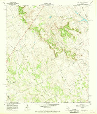
1966 Map of Camp Branch
USGS Topo · Published 1968About this map
Surprise Valley Ranch and the open Prairie land of central Texas define this mid-1960s landscape at the intersection of Erath, Bosque, and Hamilton counties. The topography is deeply carved by an intricate network of waterways, most notably the East Fork Bosque River in the northeast and the wide valley of Duffau Creek to the south. Numerous smaller tributaries like Flag Branch, Walker Branch, and Rocky Creek drain the surrounding heights, creating a series of wooded ridges and agricultural bottoms.
Find a feature on this map
19 named features on this map. Tap any name to fly to it.
Don’t see what you’re looking for? This feature index may not catch every label — zoom into the map to look around manually.
Map Details
Editions of this 1966 Camp Branch Map
This is the sole edition of this map. No revisions or reprints were ever made.
Other maps of this area

1888 · Hamilton
USGS Topo · 1:125,000

1888 · Meridian
USGS Topo · 1:125,000

1889 · Granbury
USGS Topo · 1:125,000

1890 · Stephenville
USGS Topo · 1:125,000

1894 · Hamilton
USGS Topo · 1:125,000

1894 · Meridian
USGS Topo · 1:125,000

1920 · Stephenville
USGS Topo · 1:125,000

1954 · Brownwood
USGS Topo · 1:250,000

1954 · Dallas
USGS Topo · 1:250,000

1954 · Waco
USGS Topo · 1:250,000