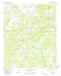
1982 Map of Camp Hill
USGS Topo · Published 1983About this map
Holly Springs National Forest dominates the southern landscape of this 1982 map, where the Wolf River and its tributaries like Turkey Creek and Sourwood Creek carve through the borderlands of Mississippi and Tennessee. Small rural communities and family-centered landmarks anchor the territory, including Hopewell and Camp Hill. The area is notably dense with small family cemeteries and country churches, such as Black Jack Ch, Mt Bethel Ch, and the Marlowe Cem, indicating a long-established pattern of local settlement.
Find a feature on this map
49 named features on this map. Tap any name to fly to it.
Don’t see what you’re looking for? This feature index may not catch every label — zoom into the map to look around manually.
Map Details
Editions of this 1982 Camp Hill Map
This is the sole edition of this map. No revisions or reprints were ever made.
Other maps of this area

1950 · Ashland
USGS Topo · 1:62,500

1950 · Middleton
USGS Topo · 1:24,000

1950 · Grand Junction
USGS Topo · 1:24,000

1951 · Middleton
USGS Topo · 1:24,000

1951 · Grand Junction
USGS Topo · 1:24,000

1951 · Walnut
USGS Topo · 1:62,500

1952 · Saulsbury
USGS Topo · 1:24,000

1956 · Blytheville
USGS Topo · 1:250,000

1956 · Tupelo
USGS Topo · 1:250,000

1958 · Tupelo
USGS Topo · 1:250,000