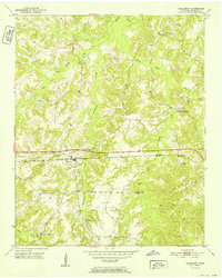
1952 Map of Saulsbury
USGS Topo · Published 1952About this map
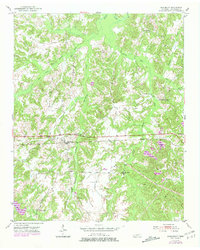
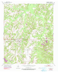
Saulsbury serves as the central hub of this 1952 topographic study, situated along the corridor of the Southern railroad. The landscape is defined by the convergence of several waterways, including Saulsbury Creek, Dry Branch, and the West Fork Spring Creek, which carve through the undulating terrain of Hardeman County. The settlement pattern reflects a mid-century rural Tennessee community anchored by family-named landmarks and local institutions. Genealogy researchers will find significant value in the distribution of burial grounds across the quadrangle, from the Saulsbury Cem near the town center to the outlying Wright Cem, Pruette Cem, and Lake Cem. Education and faith are equally well-represented, with schools like the Pleasant Grove Sch and Pleasant Hill Sch appearing alongside several country churches, including Rocks Springs Ch and West Memorial Ch.
Find a feature on this map
26 named features on this map. Tap any name to fly to it.
Don’t see what you’re looking for? This feature index may not catch every label — zoom into the map to look around manually.
Map Details
Editions of this 1952 Saulsbury Map
3 editions found
Historical Maps of Saulsbury Through Time
6 maps found