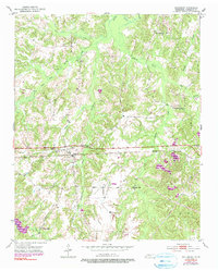
1952 Map of Saulsbury
USGS Topo · Published 1990About this map
The town of Saulsbury serves as the focal point for this mid-century survey of southwestern Tennessee, positioned at the junction of local roads and the Southern railroad line. The landscape is deeply dissected by several major drainages, including Spring Creek and its many tributaries like West Fork Spring Creek and East Fork Spring Creek. The distribution of rural landmarks suggests a well-established agrarian community, with numerous family-named burial grounds such as Wright Cem and Bruetle Cem dotting the countryside. Cultural life in the area centered on scattered educational and religious institutions, notably Pleasant Grove Sch and Rocky Springs Ch. The inclusion of Frese Pond and the headwaters of Indian Creek provide a clear view of the local hydrology before modern intensive land management altered the rural drainage patterns.
Find a feature on this map
22 named features on this map. Tap any name to fly to it.
Don’t see what you’re looking for? This feature index may not catch every label — zoom into the map to look around manually.
Map Details
Editions of this 1952 Saulsbury Map
3 editions found

Other maps of this area

1950 · Ashland
USGS Topo · 1:62,500

1950 · Hebron
USGS Topo · 1:24,000

1950 · Middleburg
USGS Topo · 1:24,000

1950 · Middleton
USGS Topo · 1:24,000

1950 · Grand Junction
USGS Topo · 1:24,000

1951 · Middleton
USGS Topo · 1:24,000

1951 · Middleburg
USGS Topo · 1:24,000

1951 · Hebron
USGS Topo · 1:24,000

1951 · Hickory Valley
USGS Topo · 1:24,000

1951 · Grand Junction
USGS Topo · 1:24,000