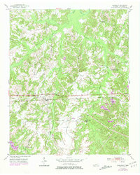
1952 Map of Saulsbury
USGS Topo · Published 1981About this map
Saulsbury sits as the central hub of this West Tennessee landscape, its development closely tied to the Southern RR railroad line that bisects the territory. The surrounding countryside is defined by the headwaters and branches of Spring Creek, which carves a network of valleys through the terrain. Notable local landmarks from this era include the Pleasant Grove Sch and Pleasant Hill Sch, which served the rural population alongside numerous country churches like West Memorial Ch and Rocky Springs Ch. Genealogists will find significant value in the documentation of family-named burial grounds, including the Pruette Cem, Lake Cem, and Antioch Cem, which are scattered among the ridges and creek bottoms. The 1980 photorevisions reveal changes in the local hydrology, specifically at Frese Pond, while the agricultural character of the land remains largely intact south of the state line.
Find a feature on this map
25 named features on this map. Tap any name to fly to it.
Don’t see what you’re looking for? This feature index may not catch every label — zoom into the map to look around manually.
Map Details
Editions of this 1952 Saulsbury Map
3 editions found

Other maps of this area

1950 · Ashland
USGS Topo · 1:62,500

1950 · Hebron
USGS Topo · 1:24,000

1950 · Middleburg
USGS Topo · 1:24,000

1950 · Middleton
USGS Topo · 1:24,000

1950 · Grand Junction
USGS Topo · 1:24,000

1951 · Middleton
USGS Topo · 1:24,000

1951 · Middleburg
USGS Topo · 1:24,000

1951 · Hebron
USGS Topo · 1:24,000

1951 · Hickory Valley
USGS Topo · 1:24,000

1951 · Grand Junction
USGS Topo · 1:24,000