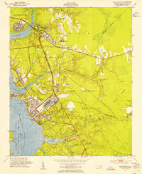
1952 Map of Camp Lejeune
USGS Topo · Published 1954About this map
Camp Lejeune Military Reservation dominates this coastal landscape, showing the installation's extensive development in the early 1950s. The map details the complex layout of the main base and nearby housing areas like Midway Park, punctuated by specialized infrastructure including a documented Road Block. Beyond the military boundaries, small communities such as Piney Green and Kellumtown represent the local civilian life surrounding the base, with several rural schools and churches like Enon Chapel and Union Chapel anchoring these settlements. The geography is defined by the tidal waters of the New River, Stump Sound, and Farnell Bay, which are fed by a network of local waterways including Northeast Creek and Wallace Creek. Extensive shoreline details, such as Hadnot Pt and Rhodes Pt, illustrate the strategic interface between the land and the coastal marshes of the White Oak region.
Find a feature on this map
43 named features on this map. Tap any name to fly to it.
Don’t see what you’re looking for? This feature index may not catch every label — zoom into the map to look around manually.
Map Details
Editions of this 1952 Camp Lejeune Map
4 editions found
Other maps of this area

1942 · Maysville
USGS Topo · 1:62,500

1942 · Swansboro
USGS Topo · 1:62,500

1943 · Jacksonville
USGS Topo · 1:62,500

1948 · Maysville
USGS Topo · 1:62,500

1948 · Swansboro
USGS Topo · 1:62,500

1948 · New River
USGS Topo · 1:62,500

1952 · Hubert
USGS Topo · 1:24,000

1952 · Camp Lejeune
USGS Topo · 1:24,000

1952 · Jacksonville South
USGS Topo · 1:24,000

1952 · Browns Inlet
USGS Topo · 1:24,000
Featured Places
- Jacksonville, NC
- Piney Green, Jacksonville
- Marine Corps Base Camp Lejeune, NC
- Pinewood Downs, Jacksonville
- Holiday Mobile Home City, Jacksonville