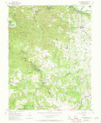
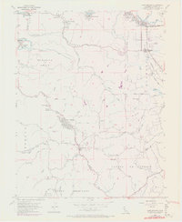
1954 Map of Camp Meeker
USGS Topo · Published 1973About this map
Bohemian Grove and the winding course of the Russian River anchor this topographic study of Sonoma County's redwood country. The map captures a landscape defined by timber and tourism, where summer retreats like Camp Meeker, Rio Dell, and Mirabel Park cluster along the waterways. The shift from mid-century rural life to modern infrastructure is visible through revisions showing El Molino High Sch and residential growth near Forestville. Deep in the canyons, old logging legacies remain evident through place names like the Redwood Tree Farm and the camps at Alliance Redwood. The rugged transition from the river valley to the coastal ridges is marked by a network of narrow roads like Harrison Grade Road and Coleman Valley Road, serving small mountain communities and historic school districts including Jonive Sch and Green Valley Sch.
Find a feature on this map
58 named features on this map. Tap any name to fly to it.
Don’t see what you’re looking for? This feature index may not catch every label — zoom into the map to look around manually.
Map Details
Editions of this 1954 Camp Meeker Map
5 editions found
Other maps of this area

1920 · Healdsburg
USGS Topo · 1:62,500

1921 · Skaggs
USGS Topo · 1:62,500

1933 · Healdsburg
USGS Topo · 1:48,000

1935 · Sebastopol
USGS Topo · 1:48,000

1940 · Healdsburg
USGS Topo · 1:62,500

1942 · Sebastopol
USGS Topo · 1:62,500

1942 · Bodega Head
USGS Topo · 1:24,000

1943 · Cazadero
USGS Topo · 1:24,000

1943 · Duncans Mills
USGS Topo · 1:24,000

1944 · Bodega Head
USGS Topo · 1:31,680