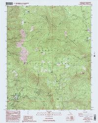
1987 Map of Camp Nelson
USGS Topo · Published 1994About this map
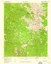
Camp Nelson serves as a central point of human settlement in this high-altitude landscape within the Sequoia National Forest. The map documents a geography defined by its ancient botanical landmarks, specifically the giant sequoia groves such as Alder Creek Grove, McIntyre Grove, and the Wheel Meadow Grove. These protected areas are interspersed with numerous high meadows, including Log Cabin Meadow and Junction Meadow, which indicate the hydraulic patterns of the Sierra Nevada. The drainage of the South Fork Tule River and the Little Kern River carve through the terrain, supporting recreation sites like the Belknap Campground and Coy Flat Campground. Evidence of forest management is seen at the Grey Meadow F S Station, while peaks like Jordan Peak and geological formations like Hermit Rock provide distinct navigational markers for those tracing historical trails or timber boundaries.
Find a feature on this map
47 named features on this map. Tap any name to fly to it.
Don’t see what you’re looking for? This feature index may not catch every label — zoom into the map to look around manually.
Map Details
Editions of this 1987 Camp Nelson Map
3 editions found
Other maps of this area

1904 · Kaweah
USGS Topo · 1:125,000

1905 · Olancha
USGS Topo · 1:125,000

1907 · Olancha
USGS Topo · 1:125,000

1909 · Kaweah
USGS Topo · 1:125,000

1937 · Kaweah
USGS Topo · 1:125,000

1948 · Fresno
USGS Topo · 1:250,000

1955 · Fresno
USGS Topo · 1:250,000

1956 · Fresno
USGS Topo · 1:250,000
1956 · Hockett Peak
USGS Topo · 1:62,500
1956 · Mineral King
USGS Topo · 1:62,500