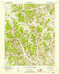
1951 Map of Campbellsville
USGS Topo · Published 1966About this map
Campbellsville and the surrounding Tennessee hill country appear here during the mid-century, characterized by a dense network of hollows and ridges along the boundary of Lawrence Co and Giles Co. The settlement at Marcella Falls sits at a geographic crossroads, anchored by the Marcella Falls Church and nearby Woodard Hollow. This landscape is deeply etched by family-named landmarks and small-scale social centers, with many of the drainage basins bearing the names of early resident families, such as Whitson Hollow, Dickey Hollow, and Morrow Hollow.
Find a feature on this map
74 named features on this map. Tap any name to fly to it.
Don’t see what you’re looking for? This feature index may not catch every label — zoom into the map to look around manually.
Map Details
Editions of this 1951 Campbellsville Map
4 editions found
Other maps of this area

1936 · Sandy Hook
USGS Topo · 1:24,000

1936 · Milky Way
USGS Topo · 1:24,000

1936 · Campbellsville
USGS Topo · 1:24,000

1936 · Lawrenceburg
USGS Topo · 1:24,000

1936 · Ethridge
USGS Topo · 1:24,000

1936 · Pulaski
USGS Topo · 1:24,000

1936 · Crestview
USGS Topo · 1:24,000

1936 · Bodenham
USGS Topo · 1:24,000

1936 · Lynnville
USGS Topo · 1:24,000

1948 · Bodenham
USGS Topo · 1:24,000